Table of Contents
SOTA by Public Transport
SOTA - Summits On The Air - is a popular activity scheme enjoyed by radio amateurs globally. The Summits are high points identified by the scheme, usually requiring some effort to get to, and often set in a rugged, sometimes remote natural landscape. The challenge is to reach a selected summit location and to use radio to communicate with other amateurs. This takes a combination of planning, expertise & technique, and a measure of determination, to achieve. Working amateur radio on a summit is known as Activation. Summits are accorded differing points according to the difficulty of operation. Accruing points in the scheme entitles participants to progressive awards to reflect incremental achievement.
The OARC (Online Amateur Radio Community) counts among its membership some keen SOTA Activators and Chasers, and a lively #portable-and-sota Discord channel.
Activating a SOTA summit uses the same radio equipment fundamentals used by the amateur operating a station from home - a transceiver and an antenna - but for SOTA, these are normally selected for optimal portability, so they will be a compromise on some technical aspects. The activator also has to prepare for spending time in the conditions on the summit, so suitable gear for dry, wet, cold or warm weather is vital.
All of that takes care of business once the activator is on location and operational.
What it doesn’t contemplate is getting there. Many activators will get to within walking distance of a SOTA summit by car - this makes sense if you have one and can drive, but what if you don’t?
The Problem
If you're a radio amateur without the use of a car, then getting to vicinity of a summit presents an additional challenge. The closest SOTA summits to home are not necessarily the easiest to get to, and finding out the most suitable route to a stop near a summit by public transport is not always straightforward either.
Fortunately, solving practical problems using a mixture of technology and collaboration is a core strength of the amateur radio community.
Problem solving starts by understanding the question.
The Question
How can I get from my home to walking distance from a SOTA summit using only public transit?
So why is that even a question? Well, journey planning apps are often bad at finding a route to a summit location which incorporates public transport, but if you can feed the planner with the summit's nearest stop as a destination, the results are much better.
Chris 2M0PVP set about thinking through how to address this and shared his thinking on #coding-and-computing on the OARC Discord server. Over the next few days, Mark 2M0IIG and Steve M1SDH provided feedback , including some patches, and Simon M0SMU, also gave input on approach and options.
Writing efficient code involved subdividing the datasets (to manage the otherwise prohibitive compute requirement), and handling differing location information (to allow for variation between data sources) which also took some iteration. The solutions also accommodate some different file formats (although further region-specific variation is expected despite established standards for transit data).
How does it work?
SOTAFilter filters SOTA summits against public transport infrastructure. The user is then free to use a journey planner app to solve the route problem more reliably. The remaining planning step is to confirm scheduling to suit the planned summit activation.
The program uses a combination of Python, Javascript and HTML, and together with downloaded publically-available data on public transport stops (NaPTAN is the national dataset for identifying public transport access points in England, Scotland and Wales) and SOTA summits to optionally deliver a summit proximity-ranked list of stops or an interactive map based on output JSON files. There is also an option to output data as .csv.
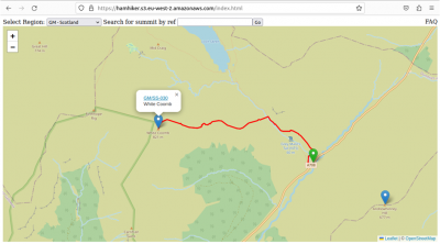
The discussion evolved along developing a map-based solution to what became (after numerous ideas and ChatGPT consults for naming suggestions) Hamhiker - a working map of pre-populated summits, bus stops and walk-in routes with top-level selection by region, and a simple search function to select a particular summit. This too took some iteration and inventive solutions to yield the desired effect. Further elaborating on the map idea, use of a route logger, such as OSMTracker (an Android app), enables the capture of a file which traces the route of an approach walk, and sharing to sites such as https://sotl.as/map so other users can join the dots with information gleaned by earlier summit activators.
Hamhiker with an example summit, nearest transit stop, and a walk-in approach route imported
Future development
SOTAFilter & Hamhiker are already useful tools to help radio amateurs in the planning phase of SOTA activations, but this is not finished work - there is room for other capabilities to augment existing functionality, and to extend or combine it’s use. Such developments are likely to exploit the interconnection between various sites and databases, and implement different approaches to improve efficiency or broaden options.
There is scope to increase usage of SOTAfilter & Hamhiker from the UK and nearby nations to a much wider catchment. Considering the potential for an increased userbase, aside from amateurs without use of a car, there is a case also for those who wish to participate in SOTA using public transport as an active choice - for example, as part of the GoGreen XOTA initiative.
Extending coverage to other countries will likely best be served by a federated approach, with others duplicating the solution (to focus on the new region) and adapting it to take into account regional format variations, for example. Looking beyond this, the project is receptive to input on other simplifying measures & improvements.
If you’d like to get involved in SOTA, this is where to start. If you’re not a member of OARC but interested in joining, click here.
Additional links:
SOTAFilter Github repository https://github.com/iron-bun/SOTAFilter
GTFS data model schematic
https://www.transitwiki.org/TransitWiki/images/f/ff/GTFS_data_model_diagram.PNG

